Tour 8 Section A - Conneaut to East Liverpool
Two thoughts went through my mind as the mud gave way under my running shoes: protect the camera; and “this is an inauspicious beginning.” And let me be clear about the second point. It wasn’t that I suddenly realized that falling down a thirty-foot embankment was poor way to start this project. It was the actual phrase “this is an inauspicious beginning,” said in a Morgan-Freeman-type-voice-over that jumped out of my subconscious as my rib-cage met the ground. After a quick inventory I determined the camera was fine and a quick change of pants in the car would take care of the mud that now coated my right side. My inner Morgan Freeman was not quite ready to move on, however, as I heard him tsking his sage disapproval.
The night before, my traveling companion Leonardo Carrizo and I had made a choice which indirectly led to me being lectured to by “the narrator.” Tour 8, our first of this project, follows what was State Route 7, “the longest, crookedest, and most variable highway in the state,” according to The Ohio Guide (TOG is as good an acronym as any I suppose). It begins in the town of Conneaut on the shores of Lake Erie a few miles from the Pennsylvania border and ends in Chesapeake on the Ohio River, which determines Ohio’s border with Kentucky. With the exception the octagon-shaped house in which Clarence Darrow was born, TOG does not list any specific points-of-interest in the seventy miles between Conneaut and Youngstown. Before we even started our journey, we thus faced our first problem: How exactly how we would use TOG? Would we stop at every site mentioned? How deeply would we explore each location? Would we get to each site by the fastest route possible?
We knew that many of these questions would (will) have to be answered as we progressed, but some guidelines were clearly in order. We decided to use TOG as the editors no doubt assumed the public would use it seventy-five years ago: as a guide. We would take complete tours when possible, sticking to the original route, and focus on those places which interest us. TOG however, has points of greater and lesser interest and like our historical counterparts, we have normal constraints of life to consider such as time, weather, available coffee, etc. So with apologies to the towns of Conneut, Andover, Kinsman, and Hubbard, we decided to begin section A of tour 8 with Youngstown; which is how I found myself getting chastised by “the narrator” as I slid down the banks of Mill Creek.
MILL CREEK PARK
Even before World War II initiated a steel boom that shaped the Mahoning Valley’s current identity, the region’s economy was based in metal. In 1802, James and Daniel Heaton set up a furnace on the banks of Yellow Creek, the current city of Struthers, where they used the ample wood supply and native limestone to smelt iron ore. When David Tod Brier found a rich vein of black coal a few miles to the north in 1844, the ingredients were in place to make Youngstown the heart of the “Ruhr Valley of America” according to TOG; an homage to the industrial and coal center in northwestern Germany. Because “Brier Hill Black” burned hotter than other coals, it didn’t require additional coking and the entire process of extracting the iron ore could be done in a single “blast” furnace. Between 1846 and 1872, twenty-one such furnaces were built in the Youngstown area.
Youngstown’s population increased with its iron production. Between 1870 and 1880 alone the population doubled, one-third of this number being recent immigrants from Wales, Germany and Ireland. These workers found themselves crowded into poorly-built company houses with equally deplorable work conditions. It was not long before strikes became commonplace. Volney Rogers, Youngstown’s visionary first city planner, wisely decided that the best way to sooth tensions between labor and ownership was to provide better living conditions for workers, including places to escape the heat and smoke of the furnaces. He helped build a trolley systems so that laborers could live further from the grime of the city (one of the reasons Ohio led the nation in inter-urban railway lines at the turn of the twentieth century) and hired Frederick Law Olmstead, the architect of New York’s Central Park, to create a pastoral refuge, including the 450-acre Mill Creek Park (now 2,882 acres).
When Rogers purchased the property that would become the park, a number of structures already existed on the site and he incorporated them into the park’s landscape; the oldest being a sandstone building James Heaton constructed in 1821 as a mill for carding and fulling wool. Pioneer Pavilion, as it would be named, was later used as a storehouse for an iron furnace from which, according to TOG, “slag from its working was dumped in the area just north of the present pavilion…[where] workmen have found billets of iron, rusty relics of the time when this was not a scenic spot but a busy little center of iron making.”
Interestingly, TOG’s only mention of the contemporary state of the furnace is that it “once stood on the hill behind [Pioneer Pavilion].” If the actual site had been located in 1940, the authors kept this information to themselves. Today, the remnants of that furnace are marked by a wooden railing and signage explaining its history. Like most of the state-funded historical sites on Tour 8A mentioned in TOG, the Pioneer Pavilion and its accompanying furnace seemed to be better demarcated in the landscape now than during the original tour.

Furnace at Pioneer Pavilion
As for the building itself, TOG does not describe the pavilion’s condition in the late 1930s, or if it was still being used as a dining and dancing facility as Rogers and Olmstead intended. However, as long as you do not bring ballons upstairs, you can still rent out this beautiful site for entertaining.

Pioneer Pavilion
Photographing Pioneer Pavilion quickly reaffirmed what I had assumed going into this project; it was going to be difficult to both take the tours and rephotograph specific sites appropriately. Nothing defines a photograph more than light and to do a rephotographic survey precisely, one needs to visit a location in the same lighting conditions as the original photograph was taken. This means not only the same time of day but the same weather conditions and even the same time of year. I knew I was not going to concern myself with the time of year, but I was hoping be able to generally match weather conditions and the time of day.
This first stop made me realize how foolish this hope had been. Even without a photograph to match, it was difficult to get the shot I wanted because of the angle of the sunlight at the time we reached the pavilion on this cloudless day (contrary to a common assumption, bright sunny days are generally the worst conditions to photograph in as it provides harsh shadows and flat, bright light). If we are going to follow the tours, I am going to have to photograph the sites in whatever lighting condition they are in when we reach them.
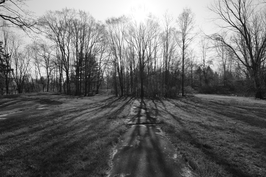
The effects of this decision are even more apparent in the following photographs of Lanterman’s Mill. While shadows in the original photograph show the photograph to be taken at 2:00 or 3:00 in the afternoon, we reached the site at 8:30 a.m. To match the photograph I would not only have to ignore my inner Morgan Freeman and climb down the muddy bank of Mill Creek (the original shot seems to have been taken from an archway in the trusses under the bridge that now has been cemented up), but my reward would be shooting directly into the sun. While this scenario caught the mist of the waterfall quite nicely, it made exposing for the mill itself a challenge.

Lanternman's Falls, @1940 / copyright Ohio Historical Society

Lanterman's Falls, 2012

Lanterman's Falls and the Old Mill, 1937 / copyright Ohio Historical Society

Lanterman Falls and Fill, 20102
As the pictures indicate, with the exception of paint in the earlier picture, both the falls and the exterior of the mill look very much like they did in 1940. And thanks to a renovation in the mid-nineteen eighties, the mill is no doubt in better shape than it was directly following the Great Depression. The third structure to sit on this site, it was originally a grist mill built by German Lanterman and his brother-in-law Samuel Kimberly in 1846. It was used until the 1870s when the advent of rollers made grind-stone milling obsolete. It stood in disrepair until 1892 when Rogers turned it into a ballroom and concession stand. Then, as TOG describes, the mill was opened as a museum in 1937 and housed a “collection of plant and animal specimens native to the region, and displays of geological, archaeological and historical materials.”
Today the mill has a more focused mission. An extensive renovation meticulously restored it to its working condition of the mid nineteenth-century so that, according to the park website, visitors can “observe the pioneer ingenuity involved in the early production of meal and flour, smell the sweet aroma of freshly ground grains, and feel the rumbling vibrations of the massive stones as the various grains are ground.”
IDORA PARK
In stark contrast to the bucolic state of Mill Creek Park are the remnants of Idora Park. Lying just a few miles south of Lanterman’s Mill and adjacent to the 2 18-hole golf courses that make up Mill Creek Golf Course, Idora Park was once the amusement center of the Youngstown area. In addition to the rides and midway that became its trademark, the grounds contained the “Pavilion Moderne, with dance floor; Heidelberg Garndens, a night club; and Idora Natatorium,” as well as “numerous picnic groves,” according to TOG.
Built by the Youngstown Park and Falls Street Railway Company in 1899 at the terminus of its south-side branch line, the park was originally constructed as a way to increase weekend ridership on this new route. Here Irish, Slovak, Polish, Italian, German and Romanian workers from around Youngstown could come together and share the thrill of riding the state-of-the-art Wildcat Roller coaster, which, as late as 1984, was still ranked as one of the 100-best roller coasters in the country. Additionally, according to TOG, these “foreign groups” held their “nationality days, commemorating dates of importance in their native lands in the park.” African-Americans, however, could only use the swimming pool and ballroom at designated times.
The park continued to operate through the early 1980s when a series of fires destroyed first the roller coasters and concessions stands and then, in 2001, the ballroom. Efforts had been put forth by conservation groups to save parts of the park’s infrastructure but ultimately only the wooden carousel, purchased by a private buyer and donated to the Brooklyn Bridge Park in NYC, was saved from the destructive fires.
A number of sites detail the history of the park. Particularly insightful is the Idora Park site from the Center For Working-Class Studies at Youngstown State University, while photographs of the abandoned but still standing site can be found at idorapark.org.
Having spent the morning exploring the two parks, Leonardo and I made our way downtown where we aimed to visit the first two points-of-interest (POI) listed in the “Cities” chapter on Youngstown and rephotograph a street scene on Federal street.
Federal Street/Soldiers Monument
Since the discovery of coal, which brought scores of eastern Europeans to work the mines, Youngstown has attracted immigrants. The early twentieth-century brought workers from the countries that would become Lebanon, Syria, and Israel, while the steel strike of 1919 and the boom of the 1940s brought tens of thousands of African-Americans from the rural south looking for work. At the time of TOG’s publication, the population of Youngstown was 170,000 with approximately 16% “foreign born” and 9% African-American, according to the U.S. Census. Today, the total population has been halved while the percentage of African-Americans has risen to approximately 45%. Less than 3% identify themselves as something other than white or black. Two hundred and forty six of those people list themselves as American Indian or Native Alaskan.
This demographic make-up was apparent as soon as we reached the center of the city. Unlike the photograph below in which a large majority of the crowd watching a parade marching down Federal Street appear to be white, to our subjective eyes, most of the people we met as we walked around Federal Plaza were black. More significant than the proportion of African-Americns, however, was the dearth of activity in general. In the middle of lunch-hour on a Friday afternoon, there were only a handful of people on the streets.
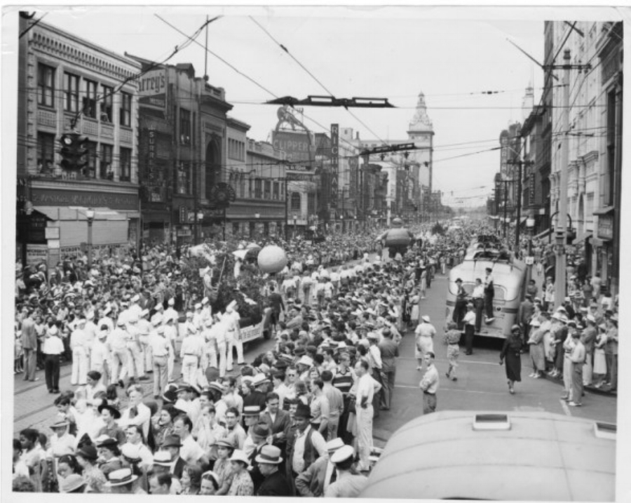
Parade Down Federal Street, @1940 / copyright Ohio Historical Society

Federal Street, 2012
A few hundred feet west of the trash can I had climbed in order to match my earlier counterpart’s view atop a bus to photograph the parade, a “47-foot granite shaft…donated by the citizens of Youngstown to honor the soldiers from the community who lost their lives in the Civil War,” supports what TOG claims the locals called “The Man on the Monument.”
When I first saw the monument’s inclusion in the TOG, it struck me as a particularly quaint reference. Perhaps due to a post-Vietnam cynicism of war, or perhaps their seeming ubiquity, tourists such as myself do not expect to see a monument to soldiers killed in a war eighty years earlier as one of the eleven must-see-sites in a city of Youngstown’s size. Yet as we traveled a region that had earned the moniker “rust belt” even before the most recent recession, it became increasingly clear that the military offers some of the best opportunities for young people to make a living. Particularly in smaller towns such as Empire and Toledo where unemployment reaches 20% and the vast majority of residence do not have more than a high-school degree, military service no doubt becomes an attractive option.

Soldier's Monument, 2012
Add to these economic incentives a tradition of military service and you have cities in which some of the most revered sites are monuments to soldiers. Throughout our trip down Route 7, houses proudly displayed signs declaring their family members’ connections to the armed forces. In towns that have lost huge portions of their populations, VFWs and American Legions were sometimes the only sings of community activity. It is no coincidence that large segments of The Deer Hunter, one of the most acclaimed movies about the problems veterans face when they return home, was filmed in Mingo Junction, one of the next stops on our tour. In contrast to my first reaction, the further into the trip we went, the more appropriate the inclusion of the Soldiers Monumentseemed.

Bellaire, Ohio, 2012
Mahoning County Courthouse
Back in Youngstown, we headed off to find the Mahoning County Courthouse, “a fine example of the Italian Renaissance style in Woodbury, Vermont, granite.” It was not the exterior I was interested in, however, but the “murals depicting four periods of law, and several others….treating local history.”
As we carried our gear up the courthouse steps, I looked fretfully at the metal detectors; there was no way the two officers guarding the door were going to let us in. Much to my surprise, they not only cheerfully let us through but directed us to Judge Krichbaum’s courtroom where we could find one of the murals. The Judge was understandably a little less enthusiastic about two guys in shorts asking to see his courtroom during his lunch hour but he instructed his bailiff to let us in and explain the story behind “The First Trial by Law in Mahoning County.”
According to the sheet of paper the bailiff gave us describing the mural, Colonel James Hillman had been riding past a salt spring in Weathersfield Township when his dog discovered the salt-maker’s body buried in the underbrush. Because the “large body of Indians who had been about Youngstown, Canfield, and Ellsworth,” could no longer be found, Hillman surmised that these were the salt-maker’s killers and went in search for them. In language that sounds as if it has not been changed since the mural was commissioned in 1909, the paper explains that the chief admitted how, after the salt-maker had given one of the “red man a drink of whiskey,” the Indian killed the man after refusing to give him more. Hillman brought said Indian back to Youngstown where his trial took place on a bluff overlooking the Mahoning River.
The mural depicts not only the dog, the judge, the prosecutor, the defense, the widow of the murdered man, and all the Indians (no tribal information is given), but also the artist, Charles Yardley Turner, who stands among a grove of Buckeyes representing civilization on the far right of the image that is gradually taking over the primeval oak forest on the left. Despite the coming of civilization, or perhaps because of it, the Indian was, according to the handout, acquitted, though no other details are given.

"The First Trial by Law in Mahoning County", 2012

Interior of Mahoning County Courthouse, 2012
Between 1985 and 1991, the county spent $8 million restoring the courthouse to its former splendor. During this time, the murals were all chemically cleaned and retouched, including the four pendenitves adorning the rotunda ceiling. Painted by Edwin Blashfield, one of the foremost muralists in the early years of the twentieth-century, these depictions of four stages in the history of law won him the gold medal of honor from the Architectural League of New York in 1911.
This information may be available more formally somewhere in the building, but we were lucky enough to learn it from Ed Black, an employee in the clerk of courts office who is known as the unofficial historian of the courthouse. As we were wandering around, we bumped into Ed who offered to show us the collection of Blashfield historical memorabilia he collected while researching the the murals during their reconditioning. In a shoebox under his desk, Ed stores a number of Blashfield relics, including photos, copies of handwritten letters, price ledgers, and an original telegram from the artist, letting his assistants know when they should expect his arrival. If you find yourself in the Mahoning County Courthouse wondering about its history, Ed is the man to talk to.

Ed Black holding photo of Edwin Blashfield, 2012
Republic Steel Company Plant / United Engineering Company Plant
As TOG makes clear, even before the boom years in the middle of the century, Youngstown’s economic and social health–though clearly not its environmental welfare–could be measured by the heat its furnaces produced:
From the city square, on nights when production is up and the mills are roaring, the horizon is painted with an uncertain light where the stack-flung ceiling of smoke gives back the glare of the mill fires. And when production is down and only a few furnaces carry ‘heats,’ the forlornness of the squat and silent mills seep into the whole city. Conversation brightens or lags with shell. ‘Are they hiring?’ ‘I hear Tube got a big order.’ ‘They’re putting in a new furnace at…’ Steel’s index production is front page news in the local papers; when it reaches the high 80’s it gets more space than the doings of Congress.
The sites of the Republic Steel Company Plant and United Engineering Company Plant lying at the base of the Market Street bridge were once part of a string of plants that ran for twenty-five miles along the Mahoning River. From the still-operating WCI plant in Warren, through Youngstown Sheet and Tube in Brier Hill, U.S. Steel and Republic Steel in the city proper, past the Campbell works of YS & T, all the way down to Lowellville, these plants gave Youngstown its identity in the twentieth century.
Then on September 19, 1977, a date still remembered by many Youngstowners as “Black Monday,” Youngstown Sheet and Tube announced it was closing its doors. This announcement was followed closely by the withdrawal of U.S. Steel in 1979 and 1980, and the bankruptcy of Republic Steel in the mid-1980s. Youngstown’s inability to diversify had dire consequences. According to Wikipedia, in the wake of the steel plant shutdowns, the community lost an estimated 40,000 manufacturing jobs, 400 satellite businesses, $414 million in personal income, and from 33 to 75 percent of the school tax revenues.
When TOG was published in 1940, about 700 hundred people worked at the United Engineering Company plant, making the equipment used in the rest of the valley’s mills. According to Rick Rowlands, President of the Youngstown Steel Heritage Foundation, the company began as the William Tod Company, making stationary steam engines. It quickly branched into making other industrial components such as the engines for Bethlehem Steel’s rolling mills and the mechanisms used to open and close the Panama canal (which are still in use today). The Tod Company also constructed the worlds first ferris wheel for the 1893 Columbian Exposition in Chicago. Today the building sits largely unused and is scheduled for demolition.

United Engineering Company Plant, 2012
On the other side of the bridge is the site of the Republic Steel Plant. Began as the Republic Iron and Steel Company in 1899, the company became one of the three largest steel producers in the country. Along with its size, however, Republic became known as the center of the “Little Steel” strike of 1937 which ultimately brought greater prosperity and increased status for steelworkers. In fact, one of the reasons Youngstown’s economic decline has been so painful for many in the community is that it represents not just a loss of jobs, but also the negation of some of the most important battles in American labor history. When the steel industry collapsed, Youngstown lost not only its most important economy but also its origin story, the narrative that gave its residents meaning of place.
So what to do with these monuments to an unreclaimable past? In the case of United Engineering, the answer to that question will come in the form of a wrecking ball. For Republic steel, it was answered when then-Congressman James Traficant secured a $26 million HUD redevelopment grant to build what became the Covelli Center, a 5,900 seat multi-purpose arena on the former mill site. The answer regarding other former steal-making sites has been less clear.

Republic Steel Corporation Buildings, @1940 / copyright Ohio Historical Society

Covelli Center, 2012
As Sherry Lee Linkon and John Russo explain in their revealing Steeltown, U.S.A; Work and Memory in Youngstown, many of Youngstown’s most powerful figures have been loathe to focus on the city’s steel-making past for fear of reinforcing the perception that Youngstown has been unable to reinvent itself. Yet ironically, the most famous relic of Youngstown’s industrial heritage, at least outside of the city, has earned that title since it was destroyed in 1997.
TOG lists the last point-of-interest as the Youngstown Sheet and Tube Company Plant. Lying just south of the city, what was known as the Campbell Works was actually only a unit of the largest millworks in the region and what would become one of the largest steel producers in the world. “In the blast and open-hearth furnaces, the rolling and strip mills, together with all the other divisions of a giant steel plant, are employed more than 7,500 men.” Today, much of the Campbell Works have been raised while the rest sits behind miles of locked chain-link fence.

Campbell Works of Youngstown Sheet and Tube, 2012

Headquarters of Campbell Works, 2012 / copyright David Bernstein

Headquarters of Campbell Works, 2012 / copyright David Bernstein
One of those “other divisions” of YS & T was the Brier Hill Plant. At its peak, the Brier Hill Plant employed 10,000 men, most of them Italian immigrants, to work its blast furnaces, “Grace” and “Jeanette.” Named after Mary Jeanette Thomas, the daughter the President of Brier Hill Steel Company, the newer furnace was “blown in” or lighted in 1918. Along with the rest of the Brier Hill Company, it was purchase by the YS & T in 1823 for whom it produced more than 11 million tons of steel in its lifetime. When Jeannette was shut down in 1977, it was one of the oldest blast furnaces in the country and the last of its kind in Youngstown. It then sat, dilapidated and empty, for twenty-years as a constant reminder of Youngstown’s inability to reinvent itself. Despite some attempts to save it, Jeannette was torn down in 1997.
Two years earlier, Bruce Sprinsgsteen released his nostalgic elegy to steelmakers, “Youngstown,” on his 1995 album, Ghost of Tom Joad.
From the Monongahela Valley,
To the Mesabi Iron Range,
The coal mines of Appalachia,
The story’s always the same.
Seven hundred tones of metal a day
Now sir, you tell me the world’s changed.
Once I made you rich enough,
Rich enough to forget my name.
Here in Youngstown. Here in Youngstown.
My sweet Jenny I’m sinking down
Here darlin’ in Youngstown.
“Jenny” is of course not a woman, but the Jeanette blast furnace at the Brier Hill Plant of the Youngstown Sheet and Tube company. While there is some debate whether workers actually called the furnace by the name Jenny, there is no doubt that thanks in large part to Springsteen, the name has become a rallying cry for those in Youngstown who want to memorialize its heritage.
And to some extent, there have been results. Due to the work of a younger generation for whom the loss of steel has not been as acute, as well as the return of some manufacturing work, there are signs that Youngstown is coming to terms with its past. The most significant indication of this turning point has been the creation of the Youngstown Historical Center of History and Labor, run by the Ohio Historical Society.
Old Stone Tavern
Just off of Route 7, in the town of Poland, lies the Stone Tavern. Technically part of tour Tour 5, we needed to pass through the town to get back on Route 7 after our visit to Campbell, so we decided to stop at the “square two-story building of sand-stone slabs erected in 1804 by Jonathan Fowler.” Originally the family home and general store, the tavern (also known as the Sparrow Tavern) became an important stop on the Pittsburgh to Cleveland Stage couch route. And as this historical marker outside the building indicates, William McKinley was sworn into the Union Army on the tavern’s front porch.

Old Stone Tavern, @1940 / copyright Ohio Historical Society

Old Stone Tavern, 2012
That porch has been replaced with a much smaller portico and the stone on the front of the building is now covered by white planking. Beyond that, the structure looks very similar to its 1940s self.. The building now holds “Old Stone Tavern Antiques,” but its future is in doubt as the “for sale” sign posted in front of the building implores passer-bys to “make offer.”
Between Youngstown and East Liverpool, Route 7 alternates between a two- and four-lane highway, replete with the standard sprawl of Rally’s and auto parts stores. As we traveled south, the landscape turned more “rural” in that the spaces between the Rally’s and auto parts stores increased, but beyond that, the scene out the window was remarkably consistent. The editors of TOG apparently felt the same way as the only information they provide for this section is that Pine Lake offers camping for $1/day, and the town of Woodworth was “terrorized by the Morgantown gang,” between 1882 and 1885. Apparently, a man named Asariah Paulin earned the moniker Old Fox by leading his seven sons and a few other relatives in a string of “burglaries, arson, and even murder,” before he was captured in Pennsylvania and sentenced to “a long term in the Ohio State Penitentiary.” Alas, we found no signs of either the Old Fox or his dastardly deeds.
East Liverpool
In 1838, James Bennett, a 28-year-old potter from Staffordshire settled in what was then known as Fawcett. Finding the clay deposits suitable for pottery, he brought his brothers from England and began to produce mugs, bowls, and teapots. Though this pottery was destroyed by a flood in 1852, enough English immigrants, particularly from Liverpool, followed Bennett’s lead that the town established itself as leading producer of the wares and even changed its name.
In 1940, 10,000 people worked producing pottery in East Liverpool. Today, the entire population barely reaches 13,000. This demographic loss has only magnified the TOG’s description of the town where “old buildings, deserted factories, and monotonous frame dwellings stand along the river front; brick kilns rise like beehives all of the city; and twisted streets zigzag their way up and over bothersome hills.” As Leonardo and I drove along the waterfront trying to figure out how to get to a street that was, according to my gps, only accessible by the railroad tracks, TOG’s claim that East Liverpool is “candidly resigned to its topography” rang especially true.

Furnace in East Liverpool, 2012
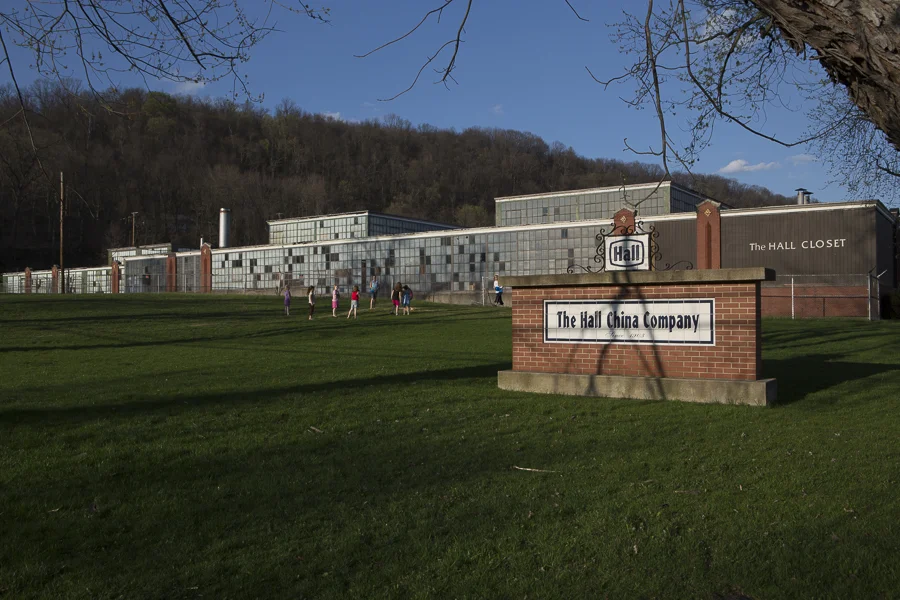
After running across one of those beehive-like kilns (currently an Ohio Historical Society site) we ultimately found our way to a development surrounding the Hall China Company Plant that was made up of those “monotonous frame dwellings.” Here, no doubt, most of the 867 people employed by the plant in 1940 lived, working at seven tunnel kilns, turning out vases, tableware, and teapots, making it the largest of the potteries in town. While the houses surrounding the plant had certainly not gotten any quainter since 1940, the neighborhood children found a suitable park in front of the plant where they were playing as we drove up. It was also the first private company we found on the tour that still existed in the same location with the same name. We would find this to be a rare event. The “seconds” retail store attached to the company should also be given some credit for its pithy name of “The Hall Closet.”
Hall China Company, East Liverpool, 2012
Unlike the residences on the water, the homes on top of and behind Diedrick’s Hill, were clearly built for a wealthier class. Here we found Thomson House on Park Boulevard, “a gray brick mansion trimmed in white with six pillars supporting a balcony over the entrance. Completed in 1906, the house was for a few years the home of William Leland Thompson, composer of ‘Darling Minnie Gray,”Softly and Tenderly,”Jesus is Calling,”and ‘My Home on the Old Ohio.'” Believe it or not, I couldn’t find any of these hits on iTunes.

hompson House, East Liverpool, 2012
East Liverpool is perhaps best known today as the home of former Notre Dame football coach Lou Holtz. In fact, the most prominent building downtown is a bank that has been turned into the Lou Holtz Hall of fame. Though at a certain time of day, even the Hall of Fame retreats into the shadows as “Crook’s Easy Terms of Credit” glows over Market Street.

"Crook's Easy Terms of Credit," East Liverpool, 2012
Addendum – Point of Beginning
A few miles east of the Hall China Company on State Route 39 one can find one of the most historically significant spots in Ohio, though TOG does not mention it. It was here, at the Point of Beginning, that geographer Thomas Hutchins began the process of surveying the Seven Ranges, opening up the Northwest Territory for American settlers and initiated the start of the U.S. Rectangular Survey. This system of land dispersal not only allowed for western expansion, but it became a tool for both the Federal government and land speculators to disposes Indian groups throughout the United States.
Initiated by Thomas Jefferson and his belief in the power Enlightenment thought, the idea was that by breaking lands into regular ordered townships, the government could control western expansion and create a system with which to administer these lands. Townships, Jefferson thought, could be broken into 36 640 acre sections that people could buy at $1/acre.
It quickly became apparent that small farmers couldn’t afford to pay for a 640 acre parcel, however. Instead, speculators bought up big chunks of land, broke them it into smaller pieces, and sold it to farmers at a tremendous profit. Congress recognized this, and over the next half-century continually reduced the minimum purchase, first to 320 acres, then 160, then 80, and eventually, in 1838, all the way to 40 acres when you could literally walk into a government land office and say “I want the northwest quarter section of section 17, township 7, range 2,” and walk out of the office with a plot of land. It couldn’t have been easier. …Unless you happen to be one of the Mingo or Shawnee or Delaware or Miami etc. who were already living on this land. But that is a story for a different day. For now it is enough to recognize the impact this system has had on the American landscape.

Satellite Image of Crops in Kansas / created by NASA, public domain
As the marker indicates, the real Point of Beginning is actually 1,112 feet south of the monument, but was moved when the road was upgraded. Approximately the same distance to the north, I shot the last picture.

Point of Beginning, 2012

S. H. Bell Company, Owners of land containing original "Point of Beginning."
Addendum to the Addendum – S. H. Bell Company
In December of 2017, I returned to East Liverpool and the Point of Beginning as part of another photography project. I asked the plant manager of the S.H. Bell Company, if I might walk onto their property and quickly take a picture of the actual "Point of Beginning." He politely declined, telling me that people might be a little uncomfortable with someone walking around with a camera right now. It turns out that the company and the neighboring residents were in the midst of a legal battle over elevated manganese levels at the industrial materials facility.